


The footpath between Lodge Hill and Keymer (DIT47) follows the route of a Roman road, now known as the Sussex Greensand Way. Possibly replacing an earlier pre-Roman trackway, the date of construction of this road is unknown. However, it probably began during the second half of the first century AD and may later have been extended eastwards towards Pevensey.
Following the free draining, east/west, ridge of greensand north of the South Downs the Greensand Way connected a number of important Roman sites between a Posting station on Stane (Stone) Street, the road linking the tribal civitas capital at Chichester (Noviomagus) to London at Hardham in the west and the late third century (circa AD 290) Roman fort at Pevensey (Anderida) in the east.
In between were probable posting stations at Stone Pound, Hassocks where the Greensand Way formed a junction with a north-south road leading to London, another such site at Bridge Farm near Barcombe Mills where it formed a junction with another north-south road leading to London and also met the River Ouse (and thus had important water transport links by river and sea), and a final roadside settlement at Arlington where it crossed the River Cuckmere which would also have provided transport opportunities by water.
At two of these postulated posting stations (Hardham and Bridge Farm) there is evidence that at some stage rectangular ditched and banked enclosures were constructed, and it is possible that, at Hassocks and Arlington, such enclosures may be awaiting discovery or have been destroyed in the past.
Such secure compounds may suggest official involvement, and we should consider that the roads involved were part of an important communications system (cursus publicus) which included the provision of accommodation and other necessities for official travellers. Such sites may also have had other official functions, such as the collection and safekeeping of taxes, especially if in the form of such things as corn. At Hassocks discoveries in the past included the remains of a large Roman cemetery.
Other important Roman sites near the Greensand Way in the vicinity of Ditchling included villas at Hurstpierpoint, Clayton, Plumpton and at Barcombe, and pottery kilns at Chiltington.
The Greensand Way was studied in detail by Ivan Margary who was the nation’s expert on Roman roads, and who included his findings in his important book Roman Ways in the Weald (1948 – London: Phoenix House publishers). Margary traced the route of the Roman road at Ditchling from Streat where he says it lies slightly south of the church, and then continues by Hayley Farm, crosses Spatham Lane at the sewage works, continues to East End [Lane], then passes just north of Rowles Croft to the foot of Lodge Hill where ‘an undisturbed piece of the flint metalling was uncovered, 9 feet wide and 3 to 6 inches thick’.
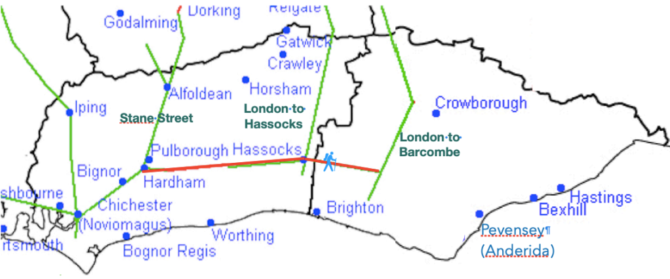
To the west of Lodge Hill Margary notes ‘there are remains of an earth agger in the fields of Court Farm [now ploughed away], followed closely by a footpath’. Margary then had some difficulty tracing the road further west into Keymer and Hassocks where it was crossed by the London-Brighton Roman road (this north-south is now thought to form a T-junction with the Greensand Way at Hassocks near Stonepound crossroads).
Dr David Rudling FSA
Sussex Archaeology and History Ltd
3rd July 2026